Saturday, November 15, 2014

The trip summery

I did stop by my old school  in Abilene, Texas which is where I met people who put me on to Santa Barbara.  It was very cold but clear so walking around campus was limited.

A few last pictures taken (while driving about 75 mph) through Arizona .


The next few shots are of the "welcome home" decorations placed by my neighbors.  They really made my return home special.
 This last one was quite a surprise, since it was after dark & turning on the light, I saw this in my kitchen (this picture was taken the next day).

Home again & all the clean up starts.......

A most fun trip with a lot of family visits & many new sights seen.   Although I only had a general idea of my route with the exception of stops to see people, I was able to take in some unique attractions.

I was gone two months + two days and drove 9,819 miles.  My days "off" the road while staying with family totaled about 25 days, which means I covered some distance on the driving days!

Seeing the U S is no small task, since there is some much of it but it is amazing!

No other thoughts to share so ...............

Monday, November 10, 2014

Baton Rouge, Louisiana 11-9-14

The morning I was to leave Florida as the sun was coming up in the sky over the Gulf of Mexico. This is the view from my hotel room with the clouds.  The white sand beaches & the water color really make it look so tropical.

On to Baton Rouge, Louisiana & a visit with my second cousin Mike Robichaux.  We last met in the early 1970 in New Orleans when I was driving back east (and we were much younger).


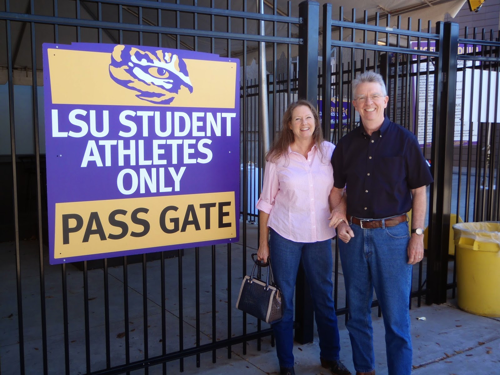
Here is Mike & his wife Teresa, who I was meeting for the first time.  They are just outside the LSU football field.


They took me over to the campus of Louisiana State University (LSU) to see the mascot of the school.


The mascot is a (real) Tiger named Mike (no, I do not think he is any relations with my cousin) but he was sleeping in his compound right on the campus.  So I took a picture of the bronze statue just out front.


We next headed to Natchez, Mississippi, a small town about 2 hours north.  It is a beautiful old town that escaped being burned during the Civil War.  Because of that the town has a lot of very early homes.  This next photos are of a Bed & Breakfast where Mike & Teresa have stayed.  We were welcomed in to see the house and garden.

This is the other side that faces the Mississippi River.


Next picture is turning right around & looking down from the high bluff (where is house is) to the Mississippi River below.  This is about 200 miles north of New Orleans where the river enters the Gulf Of Mexico.
Just down from the above shot is an old paddle wheeler river boat that has been turned into a casino. I found out that as long as the casino was not on shore, it was legal.


While in Natchez we visited an old cemetery that dates back to 1822.


There is a section devoted to Confederate unknown soldiers from the Civil War (see below).


Many of the trees like this one have what is called "Spanish Moss" hanging from them.


This is one of the older homes along the river`s edge that has been restored.


Our last stop was at the Longwood House, an old plantation home that has been preserved just as it was well over a hundred years ago.  The story is that the house was being built by "northern" craft men for a "southern" family when the Civil War broke out.  All the craft people gather up their tools and returned north, leaving the house only finished on the ground floor.  It has stood like this since then & is now open to tours.
The outside looks finished but as you will see it is only framed on the top 6 floors inside
.


The house has 8 sides and is a interesting mix of styles.  The reason for the top & the open center inside was to allow the summer heat to be vented out.   Below is the framing for the unfinished floors.


The work table / cans of material & the carpenter`s miter boxes were left untouched (along with years of dust).


One of the stair cases is just in the rough state.  Due to the safety concerns, we were not allowed to climb any higher.  The structure is made only of brick most of which were made right on the 85 acres that surround the house.


As you see below the plan called for a plaster coat to be applied to the exterior.


One last (sunset) view of the Mississippi & the casino boat.

,


I am set to hit the road on Tuesday morning and will stop for a look at my old school in Abilene, Texas.  I have not seen Hardin-Simmons University for 40 years but since I am going right through Abilene.........
After that it is a "full court press" to get home via Interstate 20 / 10 & Calif. 101!!!!
This may be the last blog for a while, until I hit the road again to "who knows where".  I hope you enjoyed sharing the trip with me.  I know there is something on the blog page about making a comment but I rarely look at these - what can I say.  That`s all folks........................................


Friday, November 7, 2014

Fort Pickens Park, Florida 11-7-14

I have now landed in Golf Breeze, Florida which is across Pensacola Bay for downtown Pensacola.   It is actually an island & fort Pickens is at the west end.  It is part of a series of cannon batteries set up to repel the British after the war of 1812.  The fort was built in 1835 and only served as a defence during the Civil War.  While being in the south it is one of four seacoast forts to remain in Union control.  It is primarily made of bricks & is mostly complete.  Pictures you say, OK.

Above is the layout with one part missing (an explosion of a power storage room took out
lower corner).  It is situated on a point of land that made it perfect to defend the bay & harbor.

Below is the main entrance which was guarded by cannons built into the walls on either side (see the second photo).


Above is a look at part of the perimeter defensive space around the fort (on the right).  It was originally 10` feet deeper than today & made for a great barrier.

See the picture below, those two stair cases (pictured at the left above) meet at the bottom but the lower part is now covered with fill dirt.


 Click once on the picture below that describes the workings of the cannon above.


These are a few of the remaining cannons on top of the walls, so of which could shoot 3 miles.  You can see in both the tracks (made of iron on top of granite) used to rotate the cannons.

 This is one of the wall cannons that when fired recoiled back on this (oak / green ) tracks, so it could be reloaded (see below).  It is amazing that it still survives 179 years later.
Some of many smaller batteries around the island are shown below - some do not still their cannons that were sold for scrap years ago.


This last one is unique in that after it fired it dropped down so it was not visible to attackers & the
 crew were protected while reloading (see below).


I think we have had enough of the hardware & there is still more, but now for a change.

The fort happens to be right across the inlet to Pensacola Bay from the Pensacola Naval Air Station. It just so happened that they were having an air show (this weekend) for which I had a "ring side" seat.  There were the usually assortment of smaller planes but the high point was a display by the Blue Angles.  With my little "point and shoot" camera the images are not very big but it was a great show.  Here are some of the best shots I got.


Again if you click once on any picture, they are "more better". T
hese last ones are the trails from the displays.


This last is a blue heron (?) that was not to impressed with the planes.  Enough & now on to Baton Rouge, La. for a visit with more family.  Tootles!


Wednesday, November 5, 2014

Hanging out in Marietta, Georgia 11-4-14

And your first question is - where is Marietta, Georgia.  Well, it is just northwest of Atlanta, Georgia. It is the home of one of my first cousin`s & her husband who have put up with me for the last several days.
They took me to Stone Mountain, a park east of Atlanta & the site of a large carving in a granite outcropping.  The carving shows three important civil war figures.  They are: Jefferson Davis; Robert E. Lee & Thomas (Stonewall) Jackson.  The large granite dome/rock that they are carved into rises 825` above the surrounding countryside.  I took the cable car ride to the top & took this picture of the carved area on the way up.


It is the high point in the area & the view on a clear day can be 60 miles.


The carved area is about three acres in size & 75` deep into the mountain.


It is not the best picture but that is downtown Atlanta in the distance, looking from on top of the Mtn.

Now for a few boring stats on Stone Mountain.

On top of this barren rock a few trees have managed to grow.

While here I been having a great visit & doing some hiking near the Chattahoochee River which runs through part of downtown Atlanta.


After seeing the sign above, all thoughts about a swim were off.

We were riding around in their car with their dog Baxter, a 85 lb. Lab.  At home he
thinks he is a lap dog.


I am heading farther south tomorrow (Thursday) to Fort Pickens State Park near Pensacola, Florida. It is right on the Gulf of Mexico and was suggested by my cousin in Baton Rouge, Louisiana.  Baton Rouge will be my next stop after checking out Fort Pickens Park.

Enough for now.  I am now heading in the direction of home but have a few places yet to stop.