Sorry no pictures again today. You might not want to see me frustrated and using colorful language.
I got up and headed for the tire store and bought a new tire. That`s done!
Then as I was driving north out of Gallup, I stopped and called the Verizon tech people again (before I got out of cell range) and in about 20 minutes the wireless router problem was fixed. Yahoo.........
The drive north was about 2.5 hours and thankfully uneventful. I landed in Farmington, New Mexico and found a trailer park with hookups and got all of my blogs updated.
Tomorrow I am headed for Aztec Ruins Nat. Montument, which is just below the border of Colorado.
After that I plan to drive to Durango, Co. I am planning to explore that area for about two or three days.
I promise more pictures tomorrow, really.
Good night
Wednesday, June 22, 2011

Day 18 - Petrified Forest - Gallup, New Mexico
It was a short drive to Gallup NM and what I thought was going to be a routine day, but....This day (Tuesday) started off when my wireless route went out and it took until Wednesday to get it fixed. While it was out I was without any way to check my emails or post anything on my blog. It was very frustrating. With several calls to Verizon tech. dept. I was able to get it up and running. Thank goodness for that.
Then I started to drive to my next destination - Chaco Canyon in New Mexico. It is in an area that is so remote that you have to drive on one of two dirt roads to get there. One road is gravel but comes in from the east side and the other one is a rocky dirt (unimproved) road that approaches from the west. Of course I chose the closer, dirt (with fist size rocks) road. I had gone about 4 miles and noticed that my steering was pulling to the right. When I stopped to check, I had a completely flat right front tire. Here I am on a mostly deserted dirt road at about 5:30 pm and nothing to do but get it changed. After almost completing the repair another car came along and stopped to ask if I was OK. While talking to him, I pointed out to him that his right front tire was also flat. We changed the tires and turned around and headed back to pavement.
I drove back to Gallup, NM and stopped for the night.
Not a fun day.................
The conclusion tomorrow............
Then I started to drive to my next destination - Chaco Canyon in New Mexico. It is in an area that is so remote that you have to drive on one of two dirt roads to get there. One road is gravel but comes in from the east side and the other one is a rocky dirt (unimproved) road that approaches from the west. Of course I chose the closer, dirt (with fist size rocks) road. I had gone about 4 miles and noticed that my steering was pulling to the right. When I stopped to check, I had a completely flat right front tire. Here I am on a mostly deserted dirt road at about 5:30 pm and nothing to do but get it changed. After almost completing the repair another car came along and stopped to ask if I was OK. While talking to him, I pointed out to him that his right front tire was also flat. We changed the tires and turned around and headed back to pavement.
I drove back to Gallup, NM and stopped for the night.
Not a fun day.................
The conclusion tomorrow............
Day 17 - Canyon de Chelly - Petrified Forest / Painted Desert

A few pictures of the Painted Desert.


I thought this one was interesting since it shows the split in the center of the log that happened before it was petrified.

This plaque is at the southern entrance to the park and talks about Stephen Mather who it says" layed the foundation of the National Park Service, established the policies that formed the service"
The End
Day 16 - Hovenweep N.M. - Canyon de Chelly N.M.
Just ease any confusion about the titles of each day - the letters (N.M.) stand for "National Monument) not New Mexico.
![]() Canyon de Chelly (pronounced "Shay") is located near the east side of Arizona and is near the northeast corner of the state
Canyon de Chelly (pronounced "Shay") is located near the east side of Arizona and is near the northeast corner of the state
It is a large series of canyons that are ringed with red sandstone cliffs. It is on the Navajo Reservation and has many Native Americans families living & farming the canyon floor. This is just as it has been for the last 5000 years according to the evidence.
![]()
![]()
![]() There are several "ruins" in the valley and I hiked down to (the only legal way to get to the valley floor) which took about 3 hours round trip - I think the elevation is about 500` from the rim down. These are the "White House Ruins" and were occupied about 1,000 years ago.
There are several "ruins" in the valley and I hiked down to (the only legal way to get to the valley floor) which took about 3 hours round trip - I think the elevation is about 500` from the rim down. These are the "White House Ruins" and were occupied about 1,000 years ago.
![]() You can see some petroglyps on the wall just below the upper ruins. Very amazing to that they have lasted all of these years.
You can see some petroglyps on the wall just below the upper ruins. Very amazing to that they have lasted all of these years.
![]() A view back up to the rim from the valley floor. If you look very closely - right in the middle of the picture is a large group of people stopped on their hike up - this will give you some scale.
A view back up to the rim from the valley floor. If you look very closely - right in the middle of the picture is a large group of people stopped on their hike up - this will give you some scale. ![]() A look at the dust cloud that the wind kicked up - this is looking west toward the town of Chinle from up on the rim drive. The dust was blowing right into the canyon and almost blacked out the sun. The next day I was going to take that truck ride into the valley floor and because of this, I did not go. As a matter of fact, I decided to get a room for the night and I am glad I did since the next day everything was coated with a fine red dust. To top it off there was a little rain that night and things were a mess in the morning. I had to stop and wash my truck before starting out - it sort of needed it anyway.
A look at the dust cloud that the wind kicked up - this is looking west toward the town of Chinle from up on the rim drive. The dust was blowing right into the canyon and almost blacked out the sun. The next day I was going to take that truck ride into the valley floor and because of this, I did not go. As a matter of fact, I decided to get a room for the night and I am glad I did since the next day everything was coated with a fine red dust. To top it off there was a little rain that night and things were a mess in the morning. I had to stop and wash my truck before starting out - it sort of needed it anyway.
That it for this day.

It is a large series of canyons that are ringed with red sandstone cliffs. It is on the Navajo Reservation and has many Native Americans families living & farming the canyon floor. This is just as it has been for the last 5000 years according to the evidence.

This one shows some of the fields that are planted wanting for the rains that usually come next month.
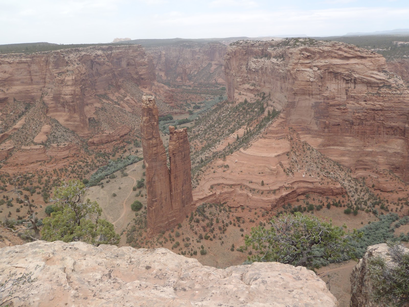
This is "Spider Rock" which stands 800` high and is important in the traditions of the Navajo people.
There are large open truck tours of the valley floor (it is the only way to enter - with one exception - the valley floor) but because of a large dust "event", I did not go. Instead I drove the two rims and checked out the vistas from the overlooks.


That it for this day.
Saturday, June 18, 2011
Day 15 - Hovenweep Nat. Monument
If you are following the text of this blog, you have deduced that I spent the night here at Hovenweep N.M. It is in the extreme southeast corner of Utah and right up against the Colorado border. It is REALLY out in the country and at night is so quiet. Daytime temps. are 85-90 and evenings are 55-60.
So what is Hovenweep all about - it is series of rock structures built starting about the 700`s and abandoned in 1277`s. They were associated with the builders of Mesa Verde Nat. Park in Colorado. They built some of the finest stone towers found anywhere. Check it out......
![]()
![]() Some of the buildings were three stories tall and are positioned around a series of canyons to create a network for communication. Most had windows set to angles lining up with each other. They span an area of about 50 square miles.
Some of the buildings were three stories tall and are positioned around a series of canyons to create a network for communication. Most had windows set to angles lining up with each other. They span an area of about 50 square miles.
![]()
![]() Many, like this one are built on top of large sandstone boulders - great foundations! I just could not help thinking that doorway has a mighty big first STEP.........
Many, like this one are built on top of large sandstone boulders - great foundations! I just could not help thinking that doorway has a mighty big first STEP.........
![]() They must have had ladders to reach some of these towers. That would have made for a great defence.
They must have had ladders to reach some of these towers. That would have made for a great defence.
![]()
![]()
![]() Some appearently did not get building permits and that caused a problem. Really the rock that the building behind is constructed on was undermined and slipped down. As a testment to the builders the walls are still attached to the large rock even though it is now a about a 45 degree tilt.
Some appearently did not get building permits and that caused a problem. Really the rock that the building behind is constructed on was undermined and slipped down. As a testment to the builders the walls are still attached to the large rock even though it is now a about a 45 degree tilt.
![]() A little something to show that in all of this desert there is some natural beauty.
A little something to show that in all of this desert there is some natural beauty.
![]() I had to travel some back roads to view these buildings but my "rig" made it without any problem.
I had to travel some back roads to view these buildings but my "rig" made it without any problem.
Well, that`s enough of these ruins. Tomorrow it is off south to Canyon de Chelly N.M. which is back in Arizona, halfway to where Hyw. 40 cuts across the state. It is still well above where the large "Wallow" fire is burning.
I have run out of "goodbys" that I can spell, so ....... See you.
So what is Hovenweep all about - it is series of rock structures built starting about the 700`s and abandoned in 1277`s. They were associated with the builders of Mesa Verde Nat. Park in Colorado. They built some of the finest stone towers found anywhere. Check it out......


I
I happened across this "ring necked" lizzard who was not to worried about me and let me take three shots before we parted company.


I went on a ranger lead hike to some petroglyphs. This one gave directions to the nearest McDonald's. Actually the spiral (they think) was a record of the travels to another dimension or what we would call heaven. The thing at the end of the spiral is the doorway - it is also the common shape of the doorways into their buildings. The shape allowed someone with a big load on their back to enter.

There are a lot of these buildings and some are even built under large rocks, like the one to the right.


Well, that`s enough of these ruins. Tomorrow it is off south to Canyon de Chelly N.M. which is back in Arizona, halfway to where Hyw. 40 cuts across the state. It is still well above where the large "Wallow" fire is burning.
I have run out of "goodbys" that I can spell, so ....... See you.
Friday, June 17, 2011
Day 14 - Natural Bridges N.M. - Hovenweep N.M. (both in Utah)
OK, so there was not a "Day 13" but it was not a Friday the 13 thing but rather I was in an area (Natural Bridges) where I did not have a "3-G" connection (I know it is hard to believe there places like that but it is the truth).
Anyway on to stuff from Day 13. I was in Natural Bridges Nat. Monument (southern Utah) and decided to hike to each of the three "bridges" form points along the road around the park. They are not to far appart and well, I did not have anything else to do......
The name of the first "bridge" is Sipapu is what the Hopi call the "gateway through which souls may pass to the spirit world". The hike down to this bridge was about 1 hour (round trip) and descended 500`.
![]()
![]()
![]() It is a little had the see since there is a 25` tree growing right in front of it (from this angle). Just wait and see the next shot....
It is a little had the see since there is a 25` tree growing right in front of it (from this angle). Just wait and see the next shot....
![]() It is about a 50` high opening and very massive supports on both sides. This bridge dropped a 4,000 pound from the underside of it`s arch in 1992 (you might be able to see the pile of rock under it). I did not read that until I had stood directly under (it was in the shade, so why not).
It is about a 50` high opening and very massive supports on both sides. This bridge dropped a 4,000 pound from the underside of it`s arch in 1992 (you might be able to see the pile of rock under it). I did not read that until I had stood directly under (it was in the shade, so why not).
The last bridge (below) is named Owachomo which in Hopi means "rock mound". It`s opening is 180` across and 106` high at the center. The hike down to it was only about 30 min. and descended 180` (piece of cake) Are you ready?
![]()
![]() And just one more? OK.
And just one more? OK.
This is what it feel like to stand under TONS of sandstone and hope it does not decide this is the moment that it FALLS DOWN!
![]()
These are a few of the shots from my drive over to Hovenweep Nat. Monument (right in the southeast corner of Utah) and it the middle of nowhere. I am surprised to be able to get a signal to post this blog from here.
The road went through some pretty impressive "cuts" and passed some very remote areas. There were even guards posted along the road........
![]() And now for those "guards on the road".
And now for those "guards on the road".
![]() This next shot looked like I was headed for a confrontation!
This next shot looked like I was headed for a confrontation!
![]() Does the term "open range" mean anything to you? Well this is it!
Does the term "open range" mean anything to you? Well this is it! ![]() I don`t know if you can see but this customer had a good sized set of horns on him, so I just waited (there was NO other traffic) for him to exit "stage right".
I don`t know if you can see but this customer had a good sized set of horns on him, so I just waited (there was NO other traffic) for him to exit "stage right".
Hovenweep N.M. is a series of stone structures built from about 700 to 1230 and then, like most was abandoned. Pictures tomorrow.
Buenas Notches.
Anyway on to stuff from Day 13. I was in Natural Bridges Nat. Monument (southern Utah) and decided to hike to each of the three "bridges" form points along the road around the park. They are not to far appart and well, I did not have anything else to do......
The name of the first "bridge" is Sipapu is what the Hopi call the "gateway through which souls may pass to the spirit world". The hike down to this bridge was about 1 hour (round trip) and descended 500`.


OK , so I had to get into the shot but it gives you an idea to the size.
The second (the drive is only one way around the monument) is named Kachina and is the youngest and thickest of the bridges. The round trip down to be able to stand right underneath was 1 hour and a decent of 400`.


The last bridge (below) is named Owachomo which in Hopi means "rock mound". It`s opening is 180` across and 106` high at the center. The hike down to it was only about 30 min. and descended 180` (piece of cake) Are you ready?


This is what it feel like to stand under TONS of sandstone and hope it does not decide this is the moment that it FALLS DOWN!

These are a few of the shots from my drive over to Hovenweep Nat. Monument (right in the southeast corner of Utah) and it the middle of nowhere. I am surprised to be able to get a signal to post this blog from here.
The road went through some pretty impressive "cuts" and passed some very remote areas. There were even guards posted along the road........


Hovenweep N.M. is a series of stone structures built from about 700 to 1230 and then, like most was abandoned. Pictures tomorrow.
Buenas Notches.
Day 12 - Amended for Pictures
I apparently did something when I loaded the pictures on "Day 12" and the right side of all of the shots was not shown. So, in a effort (often futile) I will re-post those shots here (with out all of the dribble)
![]()
![]()
![]()
![]()
![]()
![]()
![]()
![]() If you really care for the information on these shots - refer back to the original posting for Day 12.......
If you really care for the information on these shots - refer back to the original posting for Day 12.......


Subscribe to:
Posts (Atom)